SARSAT Future Enhancements
Click image to zoom
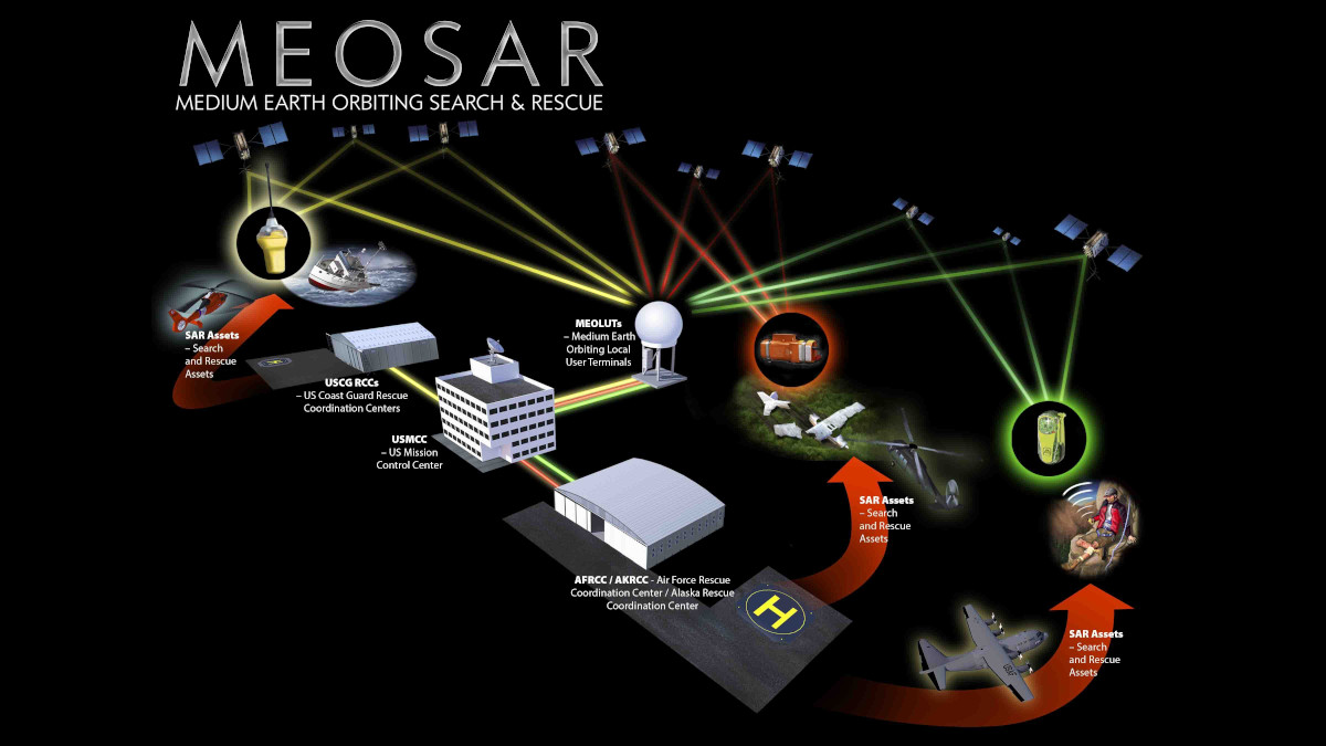
Illustration of the MEOSAR System concept including U.S. Asset Response.
A new Era in Satellite-Aided Search and Rescue
Cospas-Sarsat is an international satellite system for search and rescue (SAR) distress alerting that was established in 1979 by Canada, France, the USA and the former USSR. Since its inception the Cospas-Sarsat Programme has continually expanded both in the number of countries that have signed on to the programme and the technical advancements that continually improve the system. The goal is and always has been simple – It’s about saving lives…
With the introduction of MEOSAR satellites, the ability of Cospas-Sarsat to truly provide global coverage, near instant beacon detection and pinpoint location accuracy within minutes was now achievable. These performance parameters and a high level of satellite redundancy and availability (up to 72 satellites) meant a whole new era of system and device innovation also became possible. Some innovations were inspired by opportunities for further technological advancements that opened up when new architecture is introduced, and some were driven by heartbreaking events that demand new technologies to address the unthinkable. All of these innovations are on the cusp of being released.
Image courtesy of DIVDs
Second Generation Beacons (SGBs) will save more lives by reducing the time it takes to get to a distress.
Second Generation Beacons
With the potential of MEOSAR satellites to consistently pick up 406 distress beacon signals within minutes of activation, scientists at NASA and other international Space agencies realized that this innovation in space technology could have major implications for improving 406 beacon technology. 406 Second Generation Beacons (SGBs) are capable of sending more robust data including:
• Location Accuracy to within +/- 3 metres
• Elapsed Time since Beacon Activation which indicates either antenna masking or transmission time left
• Altitude of the Encoded Location (within 16 metres) – which could help determine what elevation the victim is likely to be found in a mountain rescue
• Time from Last Encoded Location which helps calculate the search radius to take into account a moving beacon including drift rates for a beacon at sea
• Remaining battery capacity
In terms of efficiency, SGBs front-load their distress transmissions, sending more transmissions during the first critical minutes after the beacon is activated and thereafter reduce the number of transmissions to save battery power. SGBs have two separate fields of information… The Primary field that contains embedded identification, location and other crucial information and a Secondary field that contains additional information and other fields that can be customized to customer needs.
Graphic courtesy of Cospas-Sarsat
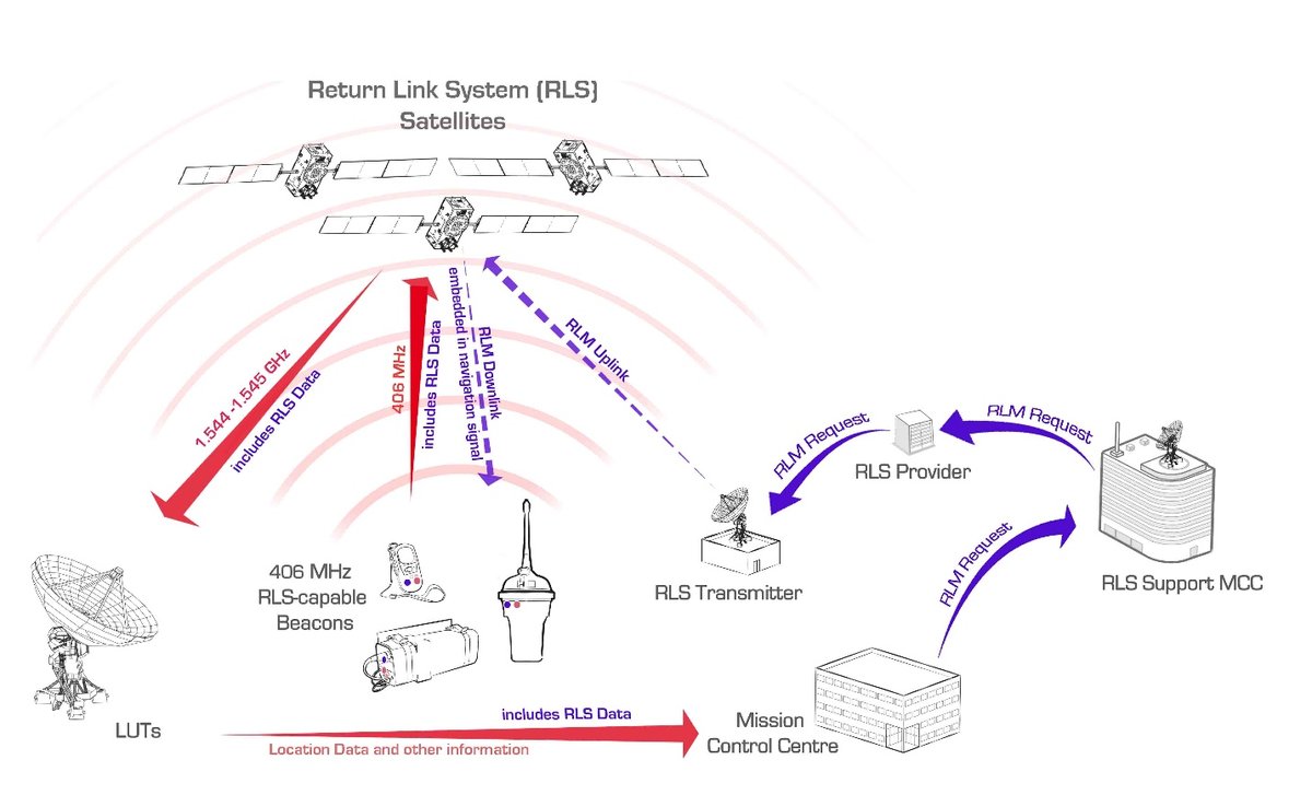
How Return Link Service reassures people in distress that help is on the way
Return Link Service
Developed by the Galileo Programme, Return Link Service (RLS) allows people in distress to receive automatic acknowledgement that their signal has been received, the location has been verified and the rescue operation is underway. According to the Galileo Programme:
“Receiving reassurance that their distress alert has been heard will deliver a valuable psychological lift to victims and further boost survival rates by reducing panic.”
This concept is based on several studies that have indicated that people will take less risks like leaving the scene of the distress, and instead stay in place, if they know that someone has heard their call for help.
This new functionality, an option that can be incorporated into SGB beacons, uses a return communication relayed by Galileo satellites, to activate the RLS message acknowledgement indicator (a blue light) on the beacon. This process takes up to 30 minutes.
The U.S. government is presently studying the possibility of including this 406 distress beacon optional feature in U.S. country coded beacons.
Graphic courtesy of ICAO
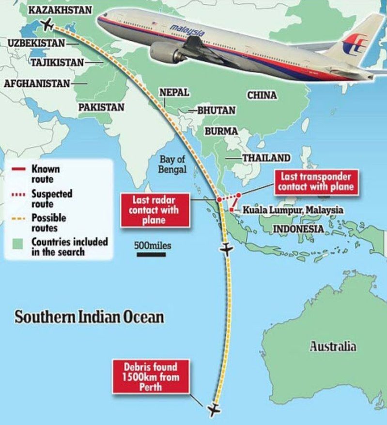
406 ELT(DT) beacons will be designed to get the aircraft position autonomously before a crash as well as help with ELT issues including being destroyed after crash or not activating at all due to the crash itself.
ELT(DT) beacons
With international civil aviation flights like the crash of Air France Flight 447 in 2009, the disappearance of Malaysia Airlines Flight 370 in 2014, and the crash of Egypt Air Flight 804 in 2016, concerns about public trust were raised and ICAO (the International Civil Aviation Organization) has responded with an operations programme called GLOBAL AERONAUTICAL DISTRESS AND SAFETY SYSTEM (GADSS). Part of that action included recognizing the need for an enhanced 406 beacon in order to get an aircraft position before an accident or crash. Cospas-Sarsat is overseeing the development of this beacon known as the Emergency Locator Transmitter for Distress Tracking (ELT(DT)). The Cospas-Sarsat 406 ELT(DT) beacon will be capable of sending an autonomous distress alert using pre-determined automatic triggers, when an aircraft shows signs of malfunction in flight. These automatic triggers include:
• Unusual Altitude
• Unusual Speed
• Imminent or potential for collision with terrain or seas
• Total loss of thrust / propulsion on all engines
The 406 ELT(DT) beacon will also be capable of being activated manually. As will all 406 alerts, the signal will be sent via MCCs to the closest RCC and transmit position, and other valuable details such as aircraft identification and country of origin. It will be capable of indicating whether the ELT(DT) is in flight or has crashed.